


Description
How to Purchase
✅ Instant Delivery (No Physical Delivery Required)
✅ Before you buy, make sure you read the Terms and Conditions
✅ If you agree to buy, you have agreed to the terms and conditions of no refunds if the reason is as described Terms and Conditions
✅ License for one PC, and cannot be transferred to another PC
✅ Licence for 1 computer (uninstall windows Licence can still be used)
✅ Active Period: Lifetime
✅ Support: Windows 10, 11
✅ Update Application: No
✅ Install Instructions: Available (video/text)
✅ It should be noted, buying = understanding product use
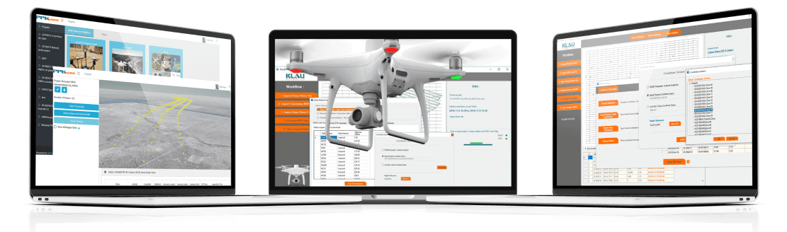
KlauPPK from Klau Geomatics is a suite of software and hardware solutions to bring accuracy to aerial mapping from drones and manned aircraft.
SOFTWARE
Save time and money
while increasing accuracy and efficiency
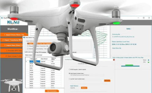
Get the best possible PPK results from your DJI drones
Mavic3 Enterprise, M300, M30, M210RTK and P4RTK
KlauPPK for DJI RTK drones
The same processing technology as our KlauPPK software (industry leading since 2015), adapted for data from DJI drones.
KlauPPK hardware is not required, just import the flight data from your drone, with base station data, to create the best possible camera positions using DJI hardware.
US$ 1250
AUD$1850
Download a free trial, right now. Full functionality for a week, to process as many jobs as you like. If you like it, contact us to buy an activation key.
KlauPPK Software customized for DJI RTK data. Process the data from your DJI in Post Processed Kinematic mode, for more reliable and acccurate results than RTK.
Better Results. No data loss or initialization loss from RTK radio link limitations. All collected data is processed with similar algorithms to RTK, run forwards and backwards through the data.
Improved Operations. PPK offers greater flexibility in operations, longer range from the base, is more reliable, more accurate and easier to use.
Proven Functionality. The same features as the KlauPPK software, proven with years of use by hundreds of customers around the world.
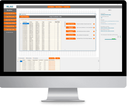
Integrated CORS base stations and MakeItAccurate. Find your nearest base station data automatically, with direct integration into NGS NOAA (USA, free), AllDayRTK (Aus/NZ) and Smartnet (global) CORS base station data repositories, or the MakeItAccurate pay per use service for high accuracy in remote areas.
- 3D Lever Arm Correction.
- Geoid and Coordinate System Support.
- Smart Geotagging.
Added efficiency, reliability and accuracy.

Pay-Per-Use Hybrid PPK/PPP Processing and Corrections Service
Compatible with any GNSS data from drones or survey equipment
MakeItAccurate is a revolutionary new post processing service. Upload your GNSS data and MakeItAccurate will apply PPK and PPP technology to make it accurate. No base station inputs required. Anywhere in the world.

Simple and Accurate with no inputs other than your drone data
Revolutionary New System. The latest PPP technology, core to the Klau Geomatics processing engine, enables highly accurate post-processing of full constellation GNSS data immediately after a mission. Achievable accuracy is 3-7cm anywhere in the world, and down to 2cm in many regions with the hybrid PPK/PPP algorithms.
The Klau Geomatics PPP processing engine accesses clock and ephemeris corrections from the satellite control stations, within 15 minutes of data capture. This results in highly accurate post-processed trajectories, anywhere, without base station data.
In many parts of the world, the KlauPPK processing engine applies sophisticated hybrid PPK/PPP algorithms, accessing up to 15 reliable CORS stations within 150km, to increase the achievable absolute accuracy to 2cm XYZ.
KlauPPK/PPP
The original KlauPPK software, since 2015, purpose-built for KlauPPK hardware systems. You will need KlauPPK hardware, which is compatible with most drones, manned aircraft and cameras.
A streamlined workflow to create accurate camera positioning in any coordinate system.
KlauPPK software enables professional users to achieve the most accurate and reliable results. PPK does not require a real-time connection to a base station. Not only does this save you time in the field, but the data collected is complete, with no losses due to communications links or range. This means better data quality, and with rigorous post-processing, the solution is more accurate and reliable than a real-time RTK solution.
The KlauPPK software solution now also offers PPP post processing for a no-base-station solution. A subscription to satellite corrections data is required for real time PPP, or the data can be pushed to MakeItAccurate for a post processed solution.
Full Software Suite to create accurate PPK or PPP camera positions in any coordinate system.
PPP Near Real Time Corrections Service to access satellite clock and ephemeris data and precise ionosphere modelling for PPP (no base station) processing.
Reviews
There are no reviews yet